According to a few sources, Tuvalu is one of the top 10 least visited countries in the world. (And it’s kind of funny that 2 others of the 10 are Kiribati and Marshalls, our next two destinations.) It is a Polynesian nation, being situated on the western side of the so-called Polynesian triangle. There is a total of 9 islands: six of them being atolls, with only 3 of those being suitable for a sailboat to enter.
The total population of Tuvalu is about 11,000 with 60% of the people living in the capital of Funafuti. Funafuti is where we started our Tuvalu adventure, and the other atoll we visited is the northernmost island, which is called Nanumea. You can see both islands on the map of Tuvalu below:
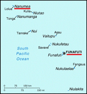
The island nation of Tuvalu
We have been to many atolls, but Funafuti is a very old one, much further on in its life cycle than any of the others we have visited. The lagoon is very deep and there are very, very few coral heads in it. The motus, or islets that form the perimeter of the atoll, are very low lying, and overall, it was not exactly the most picturesque place we’ve been to. Apparently, the atolls of Tuvalu could be the first geographical victims of higher ocean levels due to climate change. (Recall the story of the people from Vaitupu, Tuvalu who migrated to Kioa, Fiji in the 1940s due to poor soil on their home island). What I have read with the boys has said that by the end of the century these islands could be under water.
Overall, Funafuti was a very pleasant surprise, though. All of the reading I had done regarding our path north didn’t have much nice to say about the various capital “cities.” But Funafuti is a real gem. The people are very nice, even if a bit reserved at first (not unlike other Polynesian countries we’ve been in.) Things were pretty cheap and most things were available, so I really didn’t need to do 4 months worth of provisioning in Fiji.
The infrastructure is quite good and the roads are well-maintained, but you won’t find many cars driving on them. Most people get around town on scooters, or “motor-bikes” as they call them. Even though it seems like there are more scooters than people in Funafuti, you will often see several people piled on a single scooter, and helmets? Not a chance. Babies on scooters? Of course!
The air and water temperatures have of course gotten warmer as we inch closer and closer to the equator. In Funafuti we had water temperatures of approximately 89 degrees F and air temperatures even higher, so needless to say we spent a lot of time in the water. We even busted out the water hammocks from Mexico!
The main island in Funafuti, where most of the people live, is called Fongafale, and that is where we anchored most of the time. But we did venture to two other anchor locations, and you can see them all on the following satellite image.
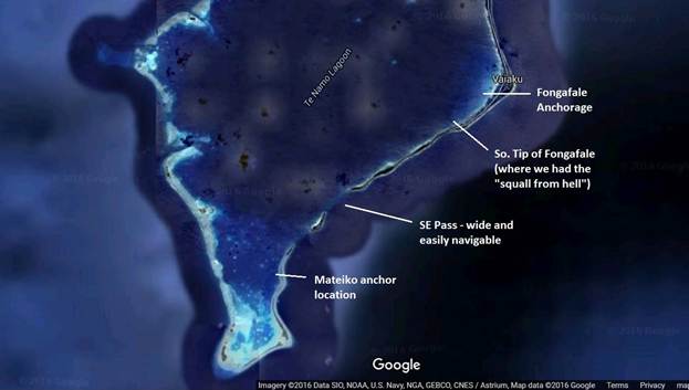
Satellite image of Funafuti
On arrival we entered through the SE pass, and it was wide and easily navigable with minimal current and no obstructions. When we departed Funafuti, we left through the northern pass, not shown on the image above, but it was equally easy, and we actually went through it with minimal light at dusk.
