We waved good-bye to True Blue V as we dropped our mooring at Anemomet on the evening of Wed, Feb 24. We timed it so that we were heading out the pass just as the last bit of light left the sky, and we were immediately slammed with 3 meter seas on the nose. After a month of sitting flat calm on moorings inside the Majuro lagoon this was a bit of a wakeup call.
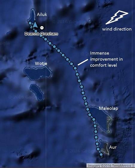
Exodus track from Majuro to Ailuk
The first night was ridiculous. I’m pretty sure I didn’t sleep a wink off-watch because I kept catching air while laying in bed. We got a little bit of relief from the sea state as we hugged the coast of Aur and Maleolap on our way by (see satellite image to the left).
The second night was a bit better, because once we reached the latitude equal with the island of Wotje we fell off the wind a bit and headed on a rumline to Ailuk.
We entered the pass on the southwest side of the atoll. There are three more commonly used passes up on the northwest side, but we thought we could save some time if we used this pass and by all means it looked viable on the satellite imagery. Unfortunately we had poor timing and when we arrived we would have had the sun in our faces as we transited the lagoon over to the village. And we had been told that Ailuk has lots of bombies in its lagoon, so we decided to wait until the sun was a little more overhead before we went in. While we waited Tim and Alex dropped the dinghy and went on a scouting mission as Brenden and I just floated around in Exodus. Once we entered the lagoon we had a couple of miserable hours bashing upwind as I stood on the roof on bombie watch. In the end I’m not sure we saved that much time since both the sun angle and the wind angle from the northern passes to the village would have been a lot better. Oh well, it’s always an adventure, and you learn as you go.
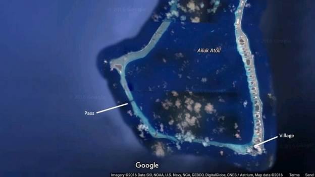
We entered Ailuk through the SW pass which meant sun in our faces and wind on our nose as we crossed over to the village
Ready to enter the pass at Ailuk
Majuro to Ailuk Passage summary:
- Duration: 1 day, 18 hrs, 47 minutes
- Route miles: 225 nmi (this is the distance of the passage route we planned in the chartplotter.)
- Track miles: 229 nmi (this is the actual distance over the ground that we traveled.)
- Log miles: 243 nmi (this is the distance derived from the log paddle wheel, so it is influenced by the current.)
- Average SOG: 5.4 kt (Speed over ground)
- Average VMG: 5.3 kt (Velocity made good)
Engine summary: Port only 0:00, Starboard only 0:00, Both 4:17 hrs
