T minus 7 days: The Big Decision
We had been on passage for five days when we were approaching Funafuti, Tuvalu, and we studied the weather forecast in order to decide what to do. Our ideal destination would be Samoa, since we ultimately wanted to get to Tonga in order to haul out Exodus for some new bottom paint and overall TLC. (If you missed the last post about the overall passage from The Marshall Islands back down to the southern hemisphere you can catch up on that narrative here: The Passage South. It sets the stage a bit for this post about TC Amos.)

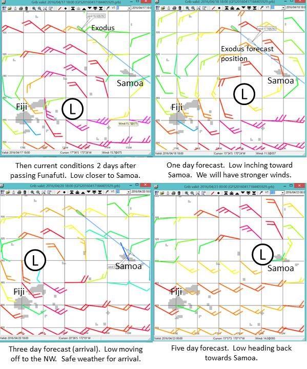
Weather forecast when we decided to bypass Funafuti and press on to Samoa
We thought we were looking at a weather gift from the gods (shown to the right). A low pressure was forecast to move west to east over Fiji before moving back off to the west and dissipating. In the southern hemisphere low pressures circulate clockwise, so this meant we could ride the top of the low with moderate NW winds on the stern almost the whole way to Samoa. Winds would eventually die and shift south which likely meant some motoring on final approach, but we would take it. If we stopped in Funafuti and the SE trades filled in, it could be a long wait before a weather window opened up again in order to head SE from Funafuti to Samoa. And even if a window opened, it could be a marginal one with a lot of upwind bashing. So, we waved to Funafuti (and our friends who were anchored there) as we passed by and changed the logbook to read, “destination: Apia, Samoa.” (Note: All of the forecasts in this post are shown in UTC. For reference, local time in Apia Samoa was UTC +13 hours.)
We understood that the decision wasn’t without risk. Being mid-April, it was the tail end of the South Pacific cyclone season, and we had already had extensive experience with how weather forecasts were notoriously unreliable beyond 2-3 days. So, we understood that there was always the chance the low pressure could strengthen beyond the current forecast and/or take a different track. We decided that we would download weather every 6 hours and if the forecast warranted, we would stop heading south or even head up to the NE to Tokelau.
T minus 5 days: Press on
Weather forecast two days after passing Funafuti. Approximately three days away from Apia, Samoa.
For about a day and a half the forecast stayed somewhat favorable. However, on day two after passing Funafuti, we downloaded a forecast that gave us some pause for concern (shown to the right). In the one day forecast the low was inching closer to us, which meant that although our winds would continue to be from a good direction they would be stronger and the overall conditions would be more volatile and squally. And ultimately, we did see 25 kts sustained with regular squalls up into the high 30s. Then the low would move off to the NW which would give us light winds (but likely still squally conditions) for arrival. But instead of continuing to the West and dissipating it was forecast to turnaround and come straight back to Samoa in a few days.
So, what to do at this point? We were approximately 3 days out from Apia, so should we implement one of our backup plans and alter course or press on? A couple of specific things influenced our decision. First was the fact that although the forecast track of the low was to head to Samoa, the forecast severity was pretty benign: about 1003 mb at worst. Second was that if we altered course and stayed at sea, there was still the possibility that we wouldn’t outrun it, so we judged it far better to face a potential cyclone in port than at sea. If we were in port, we would still be putting Exodus at risk, but we would be putting ourselves at significantly lower risk than if we stayed at sea, because we would abandon Exodus before we ever put ourselves in danger. And Exodus was insured. And we were nearing the end of our journey, so although we would surely mourn the loss of Exodus should anything happen, certainly no dreams would be dashed. We had lived those dreams already. As I write this now, it makes perfect rational sense to me, but I have to admit that at the time of the decision, we didn’t give a whole lot of credence to the idea that we were really taking any big risk with Exodus. The forecast was for a weak low, and likely the forecast track would change 96 times and not end up coming to Samoa after all. What I’m trying to say is that at the time of making this decision to press on to Samoa, I hadn’t come to any sort of inner peace with the idea of losing Exodus. It was still an abstract concept and so unlikely as to not be worthy of giving any emotional investment.
T minus 4 days: No Turning Back Now
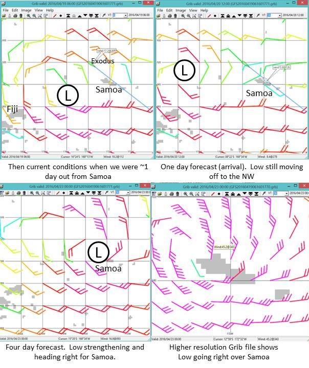
Weather forecast when we were about a day away from Apia, Samoa.
Over the next two days the forecast changed very little other than the strength of the low. Shown to the right is the forecast when we were about a day away from Samoa. It was still moving off to the West for just long enough for us to arrive but then would slam Samoa a few days after that. The two quadrants on the bottom show the same forecast, but the one on the right shows a higher resolution one that I downloaded to try and get a better perspective on the position of the low. At this point we had no other option but to press on and our only objective was to get there as soon as possible in order to prepare.
We arrived in Apia, Samoa at night on Wed, April 20 and spent the night anchored in the harbor. On Thursday morning we were granted permission to move to the marina, and then we spent most of the day clearing in, provisioning some fresh items, and getting internet access. And once we had internet access, we could monitor the storm’s progress much more easily.
T minus 2 days: Our Nemisis gets a Name
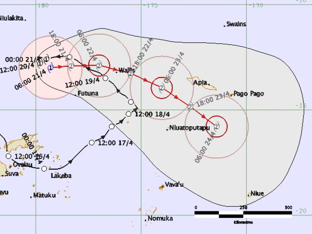
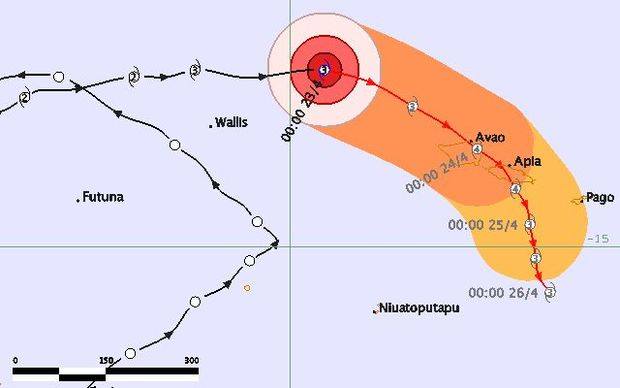
Forecast from 4/21 06:00 UTC (Thurs 7pm local time). Cat 1 Tropical Cyclone (TC) Amos forecast to strengthen to a Cat 2 and pass over Wallis and then veer to the SE
The chart to the right is for Thurs, 4/21 6:00 UTC, which was 7pm local time. The black line is the actual track and history, and the red line is the forecast. It shows that our weather gift from the gods that had given us a favorable wind direction for our passage had become a full-blown category 1 cyclone. It had also been given a name: Amos.
The chart also shows that Amos was forecast to strengthen to a category 2 and then eventually pass Samoa to the south. All things considered, it wasn’t a terribly concerning forecast if it held. We certainly weren’t panicking.
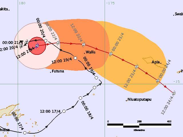
Forecast from 4/21 12:00 UTC (Fri 1am local time). Cat 2 TC Amos forecast to strenghen to a Cat 3 as it passes South of Samoa.
Just 6 hours later Amos was upgraded to a Cat 2 (chart to the right). The overall track forecast didn’t change but now it was forecast to be a Cat 3 when it passed Samoa. We still weren’t panicking, but we were definitely a little more concerned. I was obsessed with weather updates, and I decided to do some heavier provisioning, including getting all the propane tanks filled, just in case there were any infrastructure issues after the cyclone.
I should point out that when I use the cyclone category levels here, they might not be the ones you are used to, since different scales are used throughout the world. In the South Pacific, the Australian tropical cyclone intensity scale is used, which is different than the scale that’s used by the U.S. National Hurricane Center for hurricanes in the NE Pacific and Caribbean (Saffir-Simpson scale). You can see a comparison of the two scales below. So, when TC Amos was forecast to be a Cat 3, this meant sustained winds of 64-85 kt, which is roughly equivalent to a Cat 1 hurricane back home. It was only slightly comforting to tell myself that it wasn’t *really* going to be a Cat 3, it was *only* going to be a Cat 1.
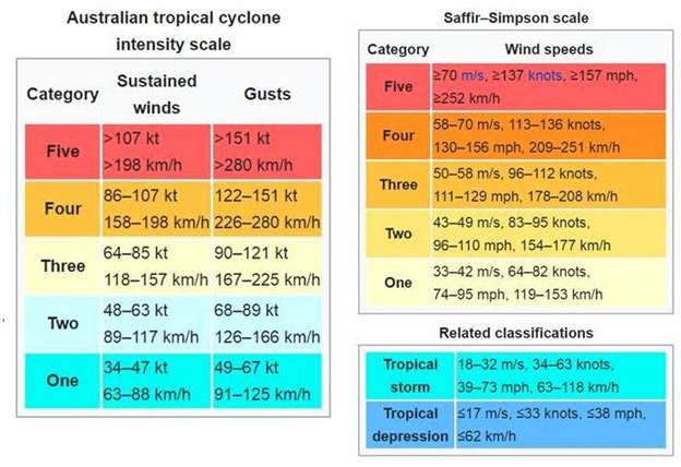
Cyclone/Hurricane intensity scale comparison. Left: Australian Scale used for South Pacific cyclones. Right: Saffir-Simpson scale used for Hurricanes in the U.S.
T minus 1 day: The Preparation
We spent most of Friday getting ready. We moved Exodus to the middle of the slip and tied dock lines to all sides. This was meant to prevent bashing into the dock on one side, depending on the direction of the wind. We stowed as much as possible and covered the dinghy so it wouldn’t collect water. Our new neighbors at the dock, Fred and Emelie from s/v Nefertiti, spent the day doing much of the same. In the evening we had an impromptu happy hour on Exodus using a little socializing to calm our nerves and feel like everything was normal. They were just starting their cruising adventure having departed from New Caledonia towards the end of the cruising season hoping to make it to French Polynesia before cyclone season kicked in. But they ended up stuck in Samoa and could barely believe they had almost made it through the cyclone season only to now be threatened by Amos. I shifted my focus from concern over ourselves and Exodus to concern over them. We were almost done cruising, and Exodus was insured. They were just starting out, and it would be heartbreaking for their dream to be interrupted by the tragedy of a cyclone. They were still intending to head to French Polynesia with plans to be married there and spend time exploring (being French, they wouldn’t be limited to a 3-month visa!) Although shifting my concern to their situation felt good and altruistic, I’m sure there was something self-serving about it. Perhaps it was a bit of a coping mechanism.
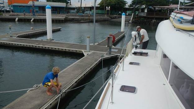
Tim and Alex getting the dock lines just right.
T minus 18 hours: Shit Gets Real
It’s good we felt prepared, because by Saturday morning shit started to get real.
The chart below shows the forecast for 4/22 18:00 UTC (Sat morning, 7am local time.) Amos was already upgraded to a Cat 3 cyclone and was forecast to graze Samoa as a Cat 4 sometime Sunday night/Monday morning. Cat 4 means sustained winds of 86-107 kts. So, we are now talking about > 100 kts sustained winds! And the geometry almost couldn’t be worse. Cyclones rotate clockwise in the Southern Hemisphere and given the direction it would be moving as it passed us, we would be in the quadrant of strongest winds. And we would see sustained winds from the North and our strongest winds from the NW as it reached its closest proximity to us.
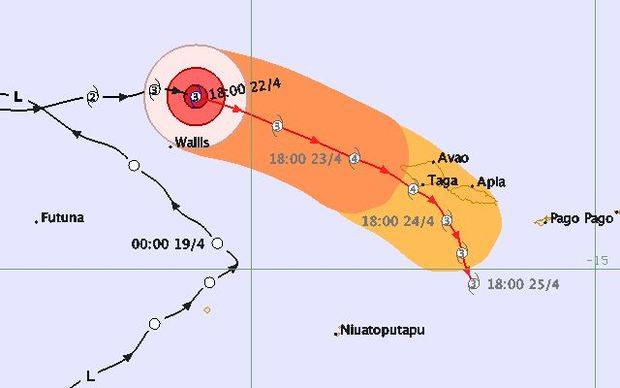
Forecast from 4/22 18:00 UTC (Sat 7am local time). Cat 3 TC Amos forecast to strenghen to a Cat 4 as it passes even closer to Apia, Samoa.
The reason this was so bad was because 1) Apia isn’t exactly a hurricane hole (understatement!) and 2) It’s wide open to the north. We were far less concerned about windspeed at this point and far more concerned about storm surge. The photos below show the geometry of Apia harbor, and you can see the small marina on the right-hand side. Sustained winds from the North to the Northwest would cause the seas to build and barrel straight into this little harbor. We had no idea how the docks would hold up with Exodus and all her weight and windage being blown by the gusts and tossed by the surge. It was important to make sure we had redundancy in the lines and that they were set for minimum chafe. Tim and Alex had already done this.
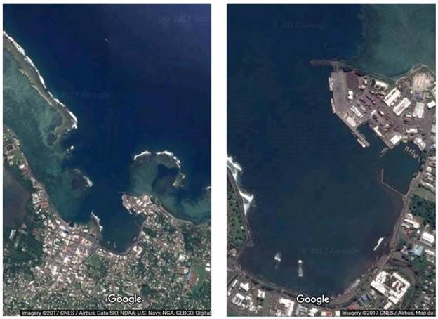
Apia Harbor is wide open to the North. In the close-up image on the right you can see the small marina on the right hand side.
Heavy rain started Saturday morning, and the forecast only got worse.
T minus 12 hours: A Direct Hit is Forecast
The chart below is from 4/23 00:00 UTC (Sat 1pm local time). It was hard to believe. Amos was now going to more or less pass right over Apia as a Cat 4 cyclone. Sustained winds 86-107 kts, gusts of 122-151 kt. We would still be in the quadrant of strongest winds, and there was just no bright side to look on. This was pretty much going to suck.
Forecast from 4/23 00:00 UTC (Sat 1pm local time). Cat 3 TC Amos forecast to strengthen to a Cat 4 as it passes pretty much right over Apia.
Tim and I didn’t talk about an evacuation plan. He is a natural optimist and an expert in crisis management, so crisis avoidance and back-up plans tend to fall in my wheelhouse. I packed a couple bags with stuff we would want to take, but just pretty much kept that activity to myself. We would leave Exodus well before it got dangerous. I recalled the people died in La Paz, Mexico during Hurricane Odile because they stayed with their boats too long. If any amount of storm surge came in and unsettled the docks, we would leave. I wasn’t sure where we would go, though, but there were concrete buildings at the marina, which should be safe as the storm blew over. I decided to pack some food too.
It was ironic. Over the course of our journey, we had travelled thousands of miles to avoid being in a hurricane zone. We had gone all the way down to New Zealand only to have TC Pam come visit us in Opua and now we had gone all the way up to The Marshalls only to arrive back just a little too early.
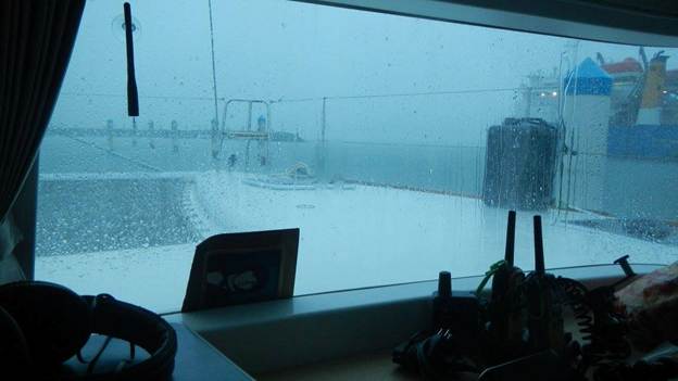
Dark skies and heavy rain on Saturday morning
T minus 6 hours: A Small Consolation
The next weather update gave us a bit of an uplift. The chart below shows the forecast at 4/23 06:00 UTC (7pm Sat local time). TC Amos was still forecast to pass right over Apia in roughly 18 hours, but the forecast was downgraded from a Cat 4 to a Cat 3. We had seen rain off and on all day with light to moderate winds from the East.

Forecast from 4/23 06:00 UTC (Sat 7pm local time). Cat 3 TC Amos forecast to remain a Cat 3 and pass right over Apia, Samoa.
We didn’t know it at the time, but Amos would pass by us much sooner than forecast and by the time we got the next weather update it would all be over. The wind started to pick up between 7-8 pm and by about 10pm it was up in the 30 kt range. The gusts became more and more violent, and Tim would periodically go out in the pouring rain and check the status of the dock lines. We didn’t keep the wind instruments on all the time, so we didn’t have a record of the highest wind speed that we saw that night, which is a bit unsatisfying because the highest gust I have recorded in the logbook is 35 kt. I’m certain we saw at least 50 (we had been on Exodus long enough, we knew the windspeed by the way it sounded blowing through the rigging). I don’t remember what time the lightning started but it was visible off to the NW and it was absolutely spectacular.
T minus 3 hours: I Can’t Sleep
I went to bed around 10pm, but I knew I wouldn’t be able to sleep. I started reading to keep my mind occupied hoping it would help me fall asleep, but not a chance. It was frustrating because at that point I thought we still wouldn’t see the worst until the morning and I wanted to be rested when that time came.
T minus zero: What!? It’s Over?
At some point after midnight, we experienced a total calm and then the wind shifted to the West.
Just after 1am Tim brought his iPad in to me to show me the updated forecast.
It was over.
Amos had already passed us and had stayed north of us the whole time. Based on that geometry we had seen our worst winds from the SE, which meant the geometry of Apia Harbor protected us from the storm surge after all. We had drinks to celebrate and then slept like babies. I never did tell Tim I had packed a bag to evacuate.
Below is the chart where I plotted Amos’s track as it passed us by that night. It was due north of us at approximately midnight and in the end, the center of the eye came as close as about 20 nmi as a Cat 3 cyclone.
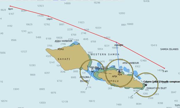
Track of TC Amos
Time to Celebrate
We had a lazy Sunday morning and managed to talk with friends via SSB and let them know how lucky we were. In my enthusiasm I was screaming into the mike and only learned later that I had woken Emelie and Fred, but they cut me some slack because they of all people understood.
We ventured out in the afternoon to find some pizza and celebrate. Overall, Samoa fared well. There was some flooding and the harbor was muddy and littered, and I read there was some road damage, but nothing extreme and certainly no loss of life.
There was a pizza place right along the harbor that was open and we were the only ones there, and the beer and pizza tasted extra good.
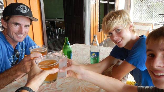
Cheers to the cyclone slayers!
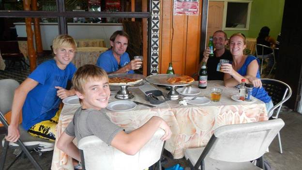
Fred and Emelie were walking back to the marina, so they joined us for our “We survived Amos” party.
