Categories
Uncategorized

Passage to Majuro

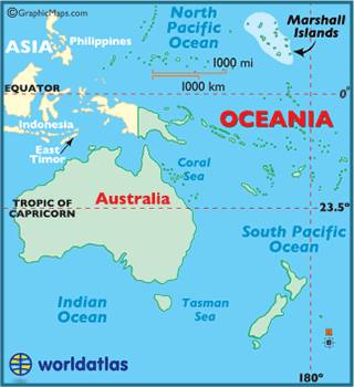
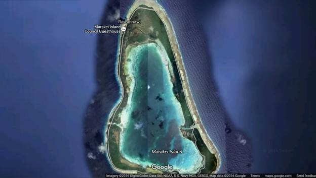
This wasn’t a long passage, but it was a particularly trying one. It was the kind of passage that makes you question what the hell you are doing out here anyway! The map below shows our inReach track that covered just over 400 nmi. You’ll notice that upon departing from Marakei we immediately started heading in the wrong direction. That’s the thing when you are dependent on the wind, sometimes you have to go in the wrong direction in order to later go in the right direction. Let me explain. Marakei is at about 2 deg N latitude, which puts it within the light, variable, squally weather of the equatorial region. We knew that once we got just a little further north that the Tradewinds would kick in, and since in the northern hemisphere they blow from the NE and we wanted to go NNW, and since Exodus is a big fat pig who doesn’t like sailing to weather, we knew we needed to get in a little easting early on while we could. (Yes, “easting” is a real word if you’re a cruiser.) So, we took advantage of the light wind in the vicinity north of Marakei and motored ENE for almost a day before making a hard left and heading in the direction of Majuro. We knew it was a good strategy, and we knew it had worked for True Blue V and others only recently, but it is still hard to be out at sea watching the VMG on your instrument display read near zero or even negative for hours on end. (VMG = Velocity Made Good = the portion of your velocity vector in the direction of your destination.) I was asleep when Tim made the left turn and by the time I was up for my watch we were bashing and bouncing into those NE trades, which would quickly, yet ever so uncomfortably, get us to Majuro.

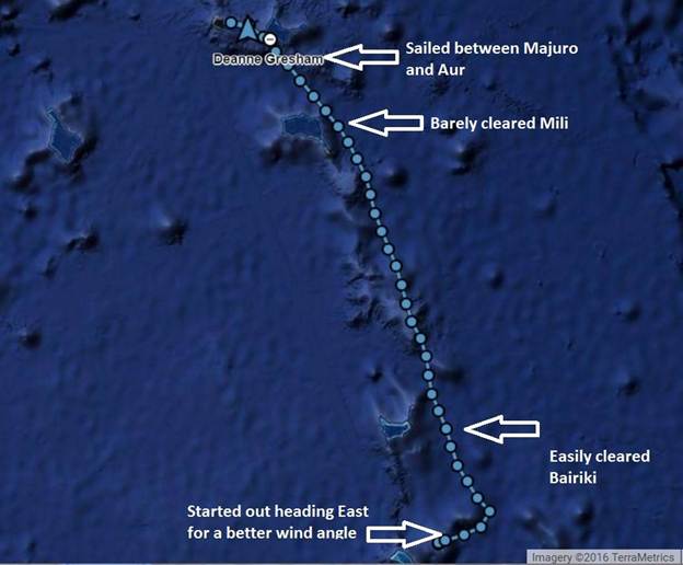
Exodus track from Marakai (Kiribati) to Majuro (Marshall Islands)

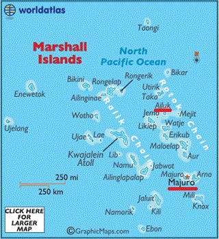
By 6am the next morning we had 20+ knots on the nose and we pointed as high into the wind as we could with the goal of clearing the west side of Butaritari and then Mili (shown on the map above). It was a horrible, bouncy, upwind ride the whole way. There aren’t a lot of notes in the logbook for this passage, which is a clear sign that I wasn’t feeling well most of the time. When we were finishing day 2 of the passage things calmed down enough so that I could sit at the computer and write, and this is from an email I sent out:

“I think the time since we left Aranuka until now has been one of my lowest points while cruising. There’s just no way to describe the way the discomfort of a severely rocking boat gets deep in your psyche and makes you want to scream or throw someone overboard, or both.”

The passage wasn’t all bad, though. We were on our way to Majuro, a place where there would be American style supermarkets with American products, so we started eating all the of the little things I had been rationing since we left Fiji: oreos, ritz crackers, pringles, canned fruit, olives, juice, etc. The boys went through lockers and bilges looking for treats I may have forgotten about (or was hiding) but sadly, the chocolate we were all hoping for was long gone.

Our entire sailing focus was trying to point high enough to be able to clear the island of Mili to the east. If we missed it and had to go around the west side that meant a lot more direct headwind (i.e., motoring) later on, which we really didn’t want to do, as much to preserve our sanity as our diesel supply. So, once we cleared Mili it lifted a mental pressure and made the boat a little bit more comfortable as we were able to fall off the wind just a tad.

Overall, this passage could have been a lot worse. The most sustained wind we had was is the low 20s and a lot of the time it was in the high teens. Most of our fleet of friend boats who had trickled into Majuro over the previous couple of weeks had experienced much higher wind speeds and bigger seas. But that’s little consolation, really.

On the last morning when I was checking into the SSB radio nets I really thought there was no chance we would make it into Majuro by the end of the day, but stronger afternoon winds kicked up and helped us speed along. By mid morning we passed by the eastern side of the atoll, which is where the actual city of Majuro is located and where all of our friends were moored. We had VHF traffic with True Blue V and it was so nice to be welcomed by them yet again. Craig was organizing a mooring for us, but we still weren’t convinced we would get there by dark because we had to go all the way to the pass and then, once inside the lagoon, all the way back down to the city of Majuro. But we took a shortcut mini-pass into the lagoon and then flew across the flat lagoon water in order to be tying up to our mooring ball as the last hints of dusk were leaving the sky.

Passage summary:

  • Duration: 3 days, 7 hrs, 31 minutes
  • Route miles: 359 nmi (this is the distance of the passage route we planned in the chartplotter.)
  • Track miles: 398 nmi (this is the actual distance over the ground that we traveled.)
  • Log miles: 461 nmi (this is the distance derived from the log paddle wheel, so it is influenced by the current. The fact that this is so much greater than our track miles implies we had a prevailing head current.)
  • Average SOG: 5 kt (Speed over ground)
  • Average VMG: 4.5 kt (Velocity made good)
  • Engine summary: Port only 0:47, Starboard only 8:49, Both 3:30
Categories
Uncategorized

Overview of The Marshall Islands

Overview of The Marshall Islands

Location of The Marshall Islands

The official name of the country is actually Republic of the Marshall Islands, or RMI. And we learned pretty quickly that they do so love their acronyms in RMI. It’s located north of the equator about halfway between Australia and Hawaii, with almost all of the islands falling between 5- and 12-degrees north latitude. It has a close relationship with the United States stemming from the fact that the U.S. gained military control of the island nation from Japan back in 1944 as a result of WWII. RMI gained independence in 1979, and although they are technically a sovereign nation today, they are still tied to the U.S. through a “Compact of Association” that was established in 1986. Basically, the U.S. has full authority and responsibility for security and defense, and Marshallese citizens can work and study in the U.S. without a visa. Furthermore, the U.S. provides monetary assistance for things like health, education, and infrastructure. And as part of the compact the U.S. military gets permission to use the lagoon and several islands of the Kwajalein atoll as a missile test range facility. Stay tuned for more about Kwajalein in my next post, since that was our destination upon departure from Ailuk.

Another aspect of the Association Compact has to do with compensation and reparations for nuclear testing that the U.S. carried out in The Marshalls between 1946 and 1962. The most notable test site was the inhabited Bikini atoll. The people of the island were “temporarily” relocated, being assured that they could move back home once testing was complete, but this of course turned out not to be the case. The testing contaminated the soil and water and made the island completely unfit for supporting life. An attempt to resettle Bikini was made in the 1970s, but this was a total debacle as it still wasn’t safe and the people who moved back there developed serious health issues. Preparations for permanent resettlement began again as far back as the early 1990s, but radiation levels even today are still considered too high for permanent settlement. Additionally, since it’s been so long since the original evacuation (70 years!) it is questionable that the descendants of the original Bikini Islanders, who have been scattered across The Marshalls (and The US) for so long, will ever permanently resettle there. Today, they run a successful dive operation for tourists at Bikini, and it is supposed to be some of the most amazing diving in the world, given that the waters and wildlife have been completely undisturbed by humans all this time. Sadly, we did not make it to Bikini, however, I’ve included this information here because it’s a tragic story that most Americans don’t really know much about. If you want to learn more: https://www.bikiniatoll.com/

Nuclear detonation just offshore of Bikini Island

Map of The Marshall Islands (Majuro and Ailuk highlighted)

There are roughly 30 or so islands that make up RMI, and most of those are very low lying atolls nearing the end of their volcanic island life cycle. Geographically the islands lie in two parallel island chains: Ratak (Sunrise) to the east and Ralik (Sunset) to the west. Majuro and Ailuk are highlighted on the map to the right, because those are the two I will be writing about in this post, but you can also see Bikini and Kwajalein, both in the Ralik chain. The total population of RMI is about 72,000 people with most people living in the capital of Majuro, which is where our adventure in RMI began…

Categories
Uncategorized

Marshall Islands Part 1 Route Recap

Three years earlier when we were roughly sketching out our “plans” for this whole trip, I never would have imagined we’d find ourselves in The Marshall Islands. Tahiti? Yes. Tonga? Yes. Fiji? Yes. But The Marshalls? I mean, had I ever even heard of it before? But if there’s only a couple of things I’ve learned in these last three years it’s that plans change and adventures can be had anywhere. Read on to hear about The Marshall Islands…

Route Recap

It was late January, and after spending slightly over a month in Kiribati, we departed the island of Marakei mid-morning on Monday, 18 Jan. The three-and-a-half-day passage up to Majuro was a crappy, upwind haul, and we had another just in time arrival as we tied up to our mooring with the last light of dusk on Thursday. One month in Majuro, the capital of The Marshalls, flew by before we finally escaped to visit some of the much more remote outer islands. We decided to head straight to the popular island of Ailuk, where we enjoyed two absolutely amazing weeks. (This chapter will cover only Majuro and Ailuk and the next chapter will cover the other islands that we visited in The Marshalls.)

(Marakai, Kiribati) –> Majuro –> Ailuk –> (Kwajalein)

Categories
Uncategorized

Looking Forward to The Marshall Islands

Next up is a little over two months in The Marshall Islands where we will sail on a traditional outrigger canoe, harvest some copra, and even take a short vacation to a small town in the U.S., and no we didn’t fly home. (Hint: Think Army base.)

Also, we’ll still be with EOS II for a while, so you’ll get to see more of this cute face:

Kiani at The George in Tarwawa

Categories
Uncategorized

Marakei

We anchored at the northwest tip of Marakai, and the first night it was reasonably calm, since the wind had more east than north in it. In the morning we were visited by the man who owns the boat we rescued, and he gave us some bananas and coconuts and invited us to shore. His name is Taukarawa, and his English was very good, since as a young man he worked on merchant ships. In fact, when he was telling me how to spell his name, he used the phonetic alphabet (tango-alpha-uniform, etc.)

Taukarawa said we could stay at the island as long as we wanted, even though we didn’t have formal permission to be there. He said it didn’t matter, since we brought back “some of their own”, we are welcome. Unfortunately, by the second night the wind had shifted to have more north than east in it and we were bouncing and rocking and rolling pretty much as if we were underway. So, we pulled away from Marakai and said goodbye to the Nation of Kiribati at about 10 am the morning of 18 January.

We anchored near the “Council Guesthouse” icon. No, that’s not a hotel.

Categories
Uncategorized

Exodus the Rescue Boat

For 3 young men in a small fishing boat, it turns out that we made a very, very good decision when we decided not to stop at Abiang. After battling light wind, no wind, squalls, and big swells, we hadn’t actually made it very far by the late afternoon. When we were about 13 nmi SE of a small island called Marakai, the guys in the skiff approached us. They didn’t speak any English, so it was hard to get their story, but we parsed together that they had been out fishing for 8 hours and now they were lost. It was overcast and there were big swells and they didn’t know which direction their island was or how far it was. Tim got out the iPad and showed them on the charts, but then it turns out that they were also very low on gas. Their first question to us was if we had gas, but they have a 2-stroke outboard and we have a 4-stroke, so we don’t carry “premix” on board.

So, we ended up doing the obvious thing and gave them a ride back to their island, towed their boat, and fed them dinner. We arrived at Marakai just as it was getting dark, and we ended up anchoring off the village on the northwest side. Unfortunately, there is no navigable pass into the lagoon at Marakai so we had to anchor on the outside, and we were hoping it would be a tolerable spot and maybe it would be our ticket to wait for a better weather window to Majuro. Anyway, I shudder to think about the fate of these guys if we hadn’t crossed paths.

Getting a ride back to Marakai

Categories
Uncategorized

Back to Tarawa

We departed Aranuka with a marginal weather window which would require us to do a big, long tack in order to make it back to Tarawa. The wind wasn’t supposed to be too strong, so beating upwind would be tolerable, plus we were supposed to have a slight wind shift from NNW to WNW which would help a lot with the tack. We weighed anchor in the afternoon at high slack tide and followed our track across the lagoon and out the pass. We headed west out of the pass and then north through the gap between Aranuka and the next-door island of Kuria. Once clear of Aranuka we headed NE just barely clearing the tip of north of Abemama and then luckily, we did end up getting that slight wind shift which helped us tack back to Tarawa. So, a half day passage turned into a 28-hour passage, and we arrived back in Tarawa just after dark. Since we were already familiar with the pass and the harbor, we had no trouble re-entering at night.

Most of the northbound fleet had already departed for Majuro, so at that point it was just us and EOS II in the bouncy Tarawa harbor. We just kept telling ourselves, “Well, at least it’s on the nose!” We spent a day getting diesel and doing light provisioning. I went back to the egg farm and scored about 28 eggs, and I was so glad not to have to share my score with the entire fleet! We cleared out on the day our visas expired, but it wasn’t a good weather window to leave, so we hunkered down in the harbor and evaluated our options.

We couldn’t head for Majuro just yet, because of hurricane Pali, which was knocking around just north of the equator to the east of our path. It was apparently the earliest ever hurricane the central pacific had ever seen. Here’s a link with some info about Pali: 

The long-range forecast showed that Pali would go right between Kiribati and Majuro, so there was no way we were going to set off until it passed. So, we decided we would leave Tarawa and go up to Abiang. We had already cleared out, so we were hoping that the existence of a hurricane would be a good enough excuse to stop without permission. EOS II left the day before us, and we had coordinated to meet up in Abiang, but the morning’s forecast had a drastic change in it. Pali had dissipated! No more hurricane risk! So, EOS II decided to not stop at Abiang but instead kept on going to Majuro. We still didn’t like the forecast for a passage to Majuro yet; even though there was no hurricane there was still 25 kts on the nose forecast, which means it will probably be more like 35, and that’s just not our style.

We departed Tarawa that evening with plans to stop at Abiang the next morning, but as we approached the pass, we decided to go ahead and hang a right, pulling an EOS II and continuing on bound for Majuro. The weather forecast was still crappy, but it wasn’t looking better anytime soon, and we didn’t have permission to go to Abiang anyway, so we decided to not even bother. It was a squally morning with erratic winds, so our plan was to motor sail east for the day before we started heading north. East might seem like a strange direction given that Majuro is actually to the west of Kiribati, but the thing is with sailing, sometimes you have to go in the wrong direction in order to get where you want to go. The whole strategy was to get east in order to have a better wind angle once we got up into the northeast trade winds. (Spoiler alert: this strategy mostly worked.)

Categories
Uncategorized

Dazzler Rum

A couple years ago we were in La Paz, Mexico for Tim’s previous 39th birthday, and our friend Dan on Dazzler gave him a cleverly wrapped bottle of rum. He used a nautical chart as the wrapping paper, and we liked it so much, Tim never unwrapped it. We’ve carried it around the Pacific all wrapped up and it became known as “The Dazzler Emergency Rum”.

Well, while we were in Abemama we ran out of Captain Morgan spiced rum (Tim’s favorite), so New Year’s Eve we finally busted into the Dazzler Emergency Rum

Thanks Dazzler!

New Year’s Eve – Getting ready to open the Dazzler Rum

Categories
Uncategorized

Good-Bye to Aranuka

Once again, I cannot overstate how much we enjoyed Aranuka. When we made the somewhat abrubt decision to leave on a marginal weather window, we spent a couple hours walking around the village and visiting people we had met in order to say good-bye. Everyone was so welcoming; I can’t tell you how many invites we had for lunch that day!

Good-bye to some of the kids of Aranuka

While saying our good-bye to Ruteru, we found out that he has an SSB radio, so once we were underway we did a radio test with him and everything seemed to be working, and he joined us for a couple of our daily nets. That was definitely a first for us… SSB traffic with one of the islanders! (Spoiler alert: it won’t be the last! Up in Marshalls one of the islanders is actually a net controller.)

Categories
Uncategorized

Period Party

Tim had plans to go fishing with Ruteru (the man with the foozeball table) but plans changed because Ruteru’s niece became a woman and there was a feast to prepare for.

The tradition is that when a girl gets her first period she only eats dried coconut for three days and then at the end of the three days they have a big feast for her to eat. The man we talked to about it said that’s the way it’s supposed to be, but probably the moms feel sorry for the girls not getting to eat anything but coconut and sneak them rice from time to time. We were invited to the party, and of course we accepted the invitation, but we weren’t sure if a gift was appropriate or not. So, Tim asked someone before the party and was told that a gift of money is generally appropriate. We considered that input, but opted to go with the gifts of nail polish, lipstick, and body spray that we have.

The party was a lot of fun, and we feasted, danced, and Tim even gave a speech to the new young woman. Alex was there this time for the dancing, and like Brenden he was also a very good sport, but sadly it was too dark for any videos. Lucky Alex. The funniest part of the night was the huge group of kids hovering around us. We jokingly call the group of kids that hover around us wherever we go “Alex’s posse” and this night was about the biggest posse we’ve seen. They actually broke down the fence they were gathered by and leaning on, and once there was no fence they infiltrated us and sat close in with us in our little corner. They don’t speak much English but there was lots of repetitive high fiving, fist bumping, and of course they absolutely loved having their pictures taken.

A man came and sat with us and talked with us during most of the party and after awhile we found out that he was the new MP, the one that beat Martin in the election. His name is Tieniti (pronounced Senis) and it turns out he was one of the men I had danced with at the Protestant party on New Year’s Day. (Not on video!)

At the end of the party the hostess presented as a gift to us one of the woven mats, and I couldn’t contain my gratitude/excitement because I’ve always really been wanting one. I told the boys when we get home we aren’t going to have furniture, just a big hand woven mat in the living room, but Tim has vetoed that. I think he misses the big comfy couch. The hostess also gave us two huge pumpkins, and Tim never tired of the joke “Oh my gourd, what are you going to do with those?!” The pumpkins were almost as exciting as the mats given we had absolutely no fresh food on board. Oh, and when you think pumpkin, don’t think big round thick skinned pumpkin that you carve at halloween, think something more like a giant zuchinni. You can even eat the skin.

With the woman of honor

Alex’s posse breakin’ down the fence

Oh my gourd!